SH 16 Bandera Road Corridor Plan
SH 16 Bandera Road Corridor Plan
Learn more about the adopted Bandera Road Corridor Plan - Phase I.
The City of San Antonio is currently engaged in a collaborative, community planning process that will culminate in the development of a multi-modal transportation, future land-use, economic development, and urban design plan for the Bandera Road Corridor. This corridor will be the first of its kind to be developed under the guidance of the SA Tomorrow Comprehensive Plan which was adopted by City Council in 2016.
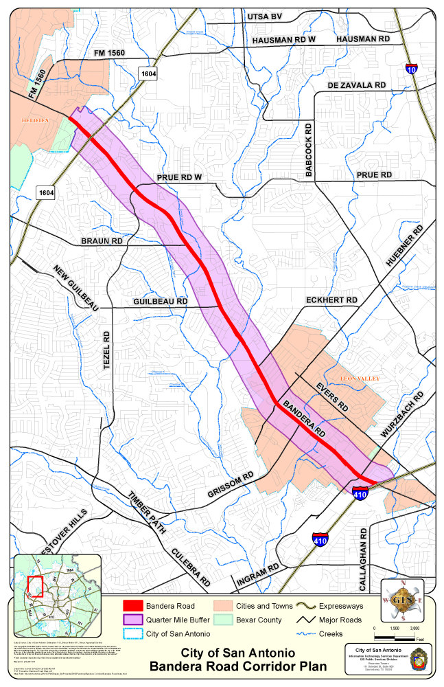
BANDERA ROAD CORRIDOR PLAN AREA
The Bandera Road Corridor plan area is primarily located in San Antonio, Texas, with an approximate 2 linear mile area bisecting the City of Leon Valley, Texas. The Bandera Road Corridor links northwest San Antonio (just inside Loop 410) and Leon Valley with Downtown San Antonio via Bandera and Culebra, connecting many crosstown routes with a direct path to the city center. The proposed Corridor Plan length is approximately 6.5 linear miles, and includes an area within one-half mile around Bandera Road, from Loop 410 to Loop 1604.
____________________________________
La ciudad de San Antonio se encuentra actualmente involucrada en un proceso de planificación comunitaria colaborativa que culminará en el desarrollo de un plan de transporte multimodal, uso futuro de la tierra, desarrollo económico y diseño urbano para el Corredor Bandera Road. Este corredor será el primero de su tipo que se desarrollará bajo la guía del Plan Integral SA Tomorrow que fue adoptado por el Concejo Municipal en el 2016.
AREA DEL PLAN DEL CORREDOR BANDERA ROAD
El área del plan del Corredor Bandera Road está ubicada principalmente en San Antonio, Texas, con un área aproximada de 2 millas lineales que dividen en dos la ciudad de Leon Valley, Texas. El corredor Bandera Road une el noroeste de San Antonio (justo dentro del Loop 410) y Leon Valley con el centro de San Antonio a través de Bandera y Culebra, conectando muchas rutas que cruzan la ciudad con un camino directo al centro de la ciudad. La longitud propuesta del Plan del Corredor es de aproximadamente 6.5 millas lineales e incluye un área dentro de media milla alrededor de Bandera Road, desde Loop 410 hasta Loop 1604.
Optional Questions: The next set of questions are optional. Your responses will remain anonymous. / Preguntas opcionales: El siguiente conjunto de preguntas son opcionales. Sus respuestas permanecerán anónimas.
Optional Questions: The next set of optional questions will help us improve our outreach efforts across the City. The information you share helps us better understand how your lived experiences contribute to your experience and perceptions in this survey. Your responses will remain anonymous.
Preguntas opcionales: El siguiente conjunto de preguntas opcionales nos ayudará a mejorar nuestros esfuerzos de divulgación en toda la ciudad. La información que comparta nos ayudará a entender mejor cómo sus experiencias vividas contribuyen a su experiencia y percepciones en esta encuesta. Sus respuestas serán anónimas.

