 Far East Community Area Plan: Survey #2
Far East Community Area Plan: Survey #2
The City of San Antonio Planning Department is gathering community input to improve the vision, goals, and focus areas for the Far East Community Area Plan ("Plan"). We are also gathering community input on the preliminary Future Land use Map to determine what should be evaluated and refined as we continue with the planning process. Please submit your feedback by completing the survey by Wednesday, December 14, 2022. For any questions, please email Dave Powell, Project Manager, for the Far East Community Area Plan at: [email protected].
El Departamento de Planificación de la Ciudad de San Antonio está reuniendo aportes de la comunidad para mejorar la visión, las metas y las áreas de enfoque para el Plan del Área Comunitaria Far East ("Plan"). También estamos recopilando información de la comunidad sobre el Mapa preliminar de uso futuro de la tierra para determinar qué se debe evaluar y refinar a medida que continuamos con el proceso de planificación. Envíe sus comentarios completando la encuesta antes del miercoles 14 de diciembre del 2022. Si tiene alguna pregunta, envíe un correo electrónico a Iris Gonzalez, Gerente de Proyectos Especiales a: [email protected].
Currently in Stage 1: Community Engagement
Community Engagement / Participación de la comunidad
This survey is will be open until Wednesday, December 14, 2022. Thank you for taking the time to make sure your voice is heard for your city!
Esta encuesta estará abierta hasta el miercoles 14 de diciembre del 2022 . ¡Gracias por su tiempo y por asegurarse de que se escuche su voz en su ciudad!
The City of San Antonio's Planning Department is requesting responses to this survey in order to gather community input that will be used to refine the Focus Areas and Future Land Use Map for the Far East Community Area Plan ("Plan").
The Plan will guide development and City decisions and investments over the next 10 years. The content of the Plan will address the following topics:
- Economic Development
- Housing
- Infrastructure and Public Space
- Land Use and Development
- Neighborhood Priorities
- Parks and Trails
- Transformative Projects
- Transportation
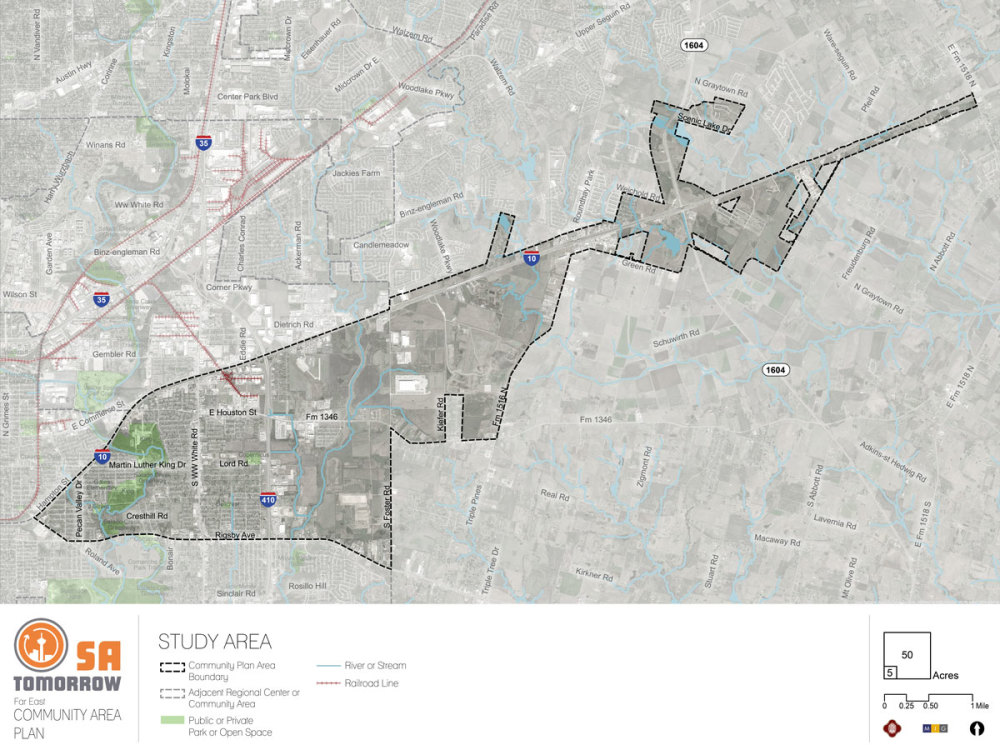
The boundaries of the Plan area are shown on the map. Please reference this map when answering questions.
El Departamento de Planificación de la Ciudad de San Antonio está solicitando respuestas a esta encuesta para recopilar aportes de la comunidad que se utilizarán para refinar las Áreas de Enfoque y el Mapa de Uso Futuro de la Tierra para el Plan del Área Comunitaria Far East ("Plan").
El Plan guiará las decisiones e inversiones de desarrollo y de la Ciudad durante los próximos 10 años. El contenido del Plan abordará los siguientes temas:
- Desarrollo economico
- Vivienda
- Infraestructura y Espacio Público
- Uso y desarrollo de la tierra
- Prioridades del vecindario
- Parques y Senderos
- Proyectos Transformadores
- Transportación
Los límites del área del Plan se muestran en el siguiente mapa. Consulte este mapa cuando responda las preguntas
Draft Vision
The draft Vision for the Far East Community Area Plan was created using community input. Please review the draft Vision:
The Far East Community Area is comprised of safe and inviting neighborhoods with diverse, quality, and affordable options for housing, dining, shopping, medical services, healthy food, and community gathering spaces, all organized around quality parks and the area’s own walkable arts, entertainment and shopping district. Residents of all ages and incomes can get around easily using well-lit and well-maintained sidewalks, trails, bicycle facilities, and transit amenities lined with trees and landscaping, green stormwater treatments, and public art.
Borrador de la visión
El borrador de la Visión para el Plan del Área Comunitaria Far East se creó utilizando los aportes de la comunidad. Por favor revise el borrador de la visión:
El Área Comunitaria del Far East se compone de vecindarios seguros y acogedores con opciones diversas, accesibles y de calidad para viviendas, restaurantes, tiendas, servicios médicos, alimentos saludables y espacios de reunión comunitaria, todo organizado alrededor de parques de calidad y artes transitables propias del área, zona comercial y de recreación. Los residentes de todas las edades e ingresos pueden moverse fácilmente utilizando banquetas,senderos, instalaciones para bicicletas y servicios de tránsito bien iluminados y mantenidos bordeados de árboles y jardines, tratamientos de aguas pluviales verdes y arte público.
Draft Goals
The draft Goals for the Far East Community Area Plan were created using community input. Please review the draft Goals:
Goal 1: Improve comfort and safety throughout the area with improved lighting, signage, and enhancement of parks, trails, sidewalks, and other community assets.
Goal 2: Increase access to healthy food and health care for all residents.
Goal 3: Facilitate development patterns that include local employment and entertainment opportunities in one or more mixed use urban centers or arts districts that are highly walkable and connected and serve as an area destination.
Goal 4: Increase equitable access to parks, open space, trails, community gathering facilities, and recreational amenities.
Goal 5: Create housing, employment, goods and services that serve, support and are accessible to a variety of income levels, age groups, and multi-generational households.
Goal 6: Encourage commercial development to be less auto-oriented and more walkable and provide a greater diversity of locally serving restaurant and retail options.
Goal 7: Improve comfort, safety and aesthetics throughout the Far East Area with tree-lined streets, other urban greening, and integration of sustainable infrastructure.
Goal 8: Expand the amount and variety of multi-modal networks throughout the Far East Area.
Borrador de los objetivos
El borrador de los objetivos para el Plan del Área Comunitaria Far East se creó utilizando los aportes de la comunidad. Revise el borrador de los objetivos:
Objetivo 1: Mejorar la comodidad y la seguridad en toda el área con mejor iluminación, señalización y realce de parques, senderos, banquetasy otros lugares accesibles a la comunidad.
Objetivo 2: Aumentar el acceso a alimentos saludables y atención médica para todos los residentes.
Objetivo 3: Facilitar patrones de desarrollo que incluyan empleo local y oportunidades de entretenimiento en uno o más centros urbanos de uso mixto o distritos de arteque sean altamente transitables y conectados, y que sirvan como un destino del área.
Objetivo 4: Aumentar el acceso equitativo a parques, espacios abiertos, senderos, instalaciones de reunión comunitaria y servicios recreativos.
Objetivo 5: Crear viviendas, empleos, bienes y servicios que sirvan, apoyen y sean accesibles para personas con diferentes niveles de ingresos, edades y hogares multigeneracionales.
Objetivo 6:Promover el desarrollo comercial para que esté menos orientado a los automóviles y sea más transitable a pie, y proporcione una mayor diversidad de opciones de restaurantes y tiendas minoristas que sirvan localmente.
Objetivo 7: Mejorar la comodidad, la seguridad y la estética en toda el Área del Far East con calles arboladas, otras zonas verdes urbanas, así como la integración de infraestructura sostenible.
Objetivo 8: Expandir la cantidad y variedad de redes multimodales en toda el Área del Far East.
Draft Focus Areas
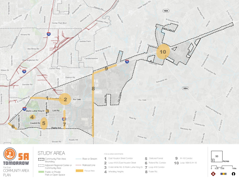
Focus areas are, or will be, important areas of opportunity to direct future investments, support, or improvements. Focus areas were initially identified using community input. Your answers to the questions will help us refine focus areas for the Far East Community Area. The map shows a total of ten proposed focus areas for the Far East Community Area, which are as follows:
- East Houston Street Corridor
- Loop 410 & East Houston Street
- S WW White Rd. & Martin Luther King Dr.
- Wheatley Heights
- Dellcrest Forrest
- Roland Rd. Corridor
- Loop 410 Corridor
- Foster Rd.
- IH-10 Corridor
- Loop 1604 & IH-10
Borrador de áreas de enfoque
Las áreas de enfoque son, o serán, importantes áreas de oportunidad para dirigir futuras inversiones, apoyo o mejoras. Las áreas de enfoque se identificaron inicialmente utilizando los aportes de la comunidad. Sus respuestas a las siguientes preguntas nos ayudarán a refinar las áreas de enfoque para el Área del Far East. El siguiente mapa muestra un total de diez áreas de enfoque propuestas para el Área Comunitaria Far East, que son las siguientes:
- Corredor de Calle East Houston
- Loop 410 y East Houston Street
- S WW White Rd. y Martin Luther King Dr.
- Wheatley Heights
- Dellcrest Forrest
- Corredor de Roland Rd.
- Corredor de Loop 410
- Foster Rd.
- Corredor de IH-10
- Loop 1604 y IH-10
Working Draft Future Land Use Map
Land use is a term to describe the uses that exist or are envisioned on a property. It is generally broken down into categories, such as:
- Residential (e.g. houses, duplexes, apartments)
- Commercial (e.g. stores, restaurants, offices)
- Industrial (e.g. manufacturing, distribution facilities)
- Mixed-Use (e.g. stores on first level and apartments above or retail and homes on the same property)
- Government and Parks/Open Space (e.g. public parks, government facilities)
The Future Land Use Map identifies how land can be used in the future. It defines how a property can be rezoned in the future, it sets guides for elected officials deciding rezoning cases, it ensures that project growth can be absorbed in an orderly way throughout the City, and it establishes the preferred mixtures of uses and the distribution of density in various areas of the City, based on public input and feedback.
Borrador del Mapa de Uso Futuro de la Tierra
El uso de la tierra es un término para describir los usos que existen o se prevén en una propiedad. Generalmente se divide en categorías, tales como:
- Residencial (por ejemplo, casas, dúplex, apartamentos)
- Comercial (por ejemplo, tiendas, restaurantes, oficinas)
- Industrial (p. ej., fabricación, instalaciones de distribución)
- Uso mixto (p. ej., tiendas en el primer nivel y apartamentos arriba o tiendas y casas en la misma propiedad)
- Gobierno y parques/espacios abiertos (p. ej., parques públicos, instalaciones gubernamentales)
El Mapa de uso futuro de la tierra identifica cómo se puede usar la tierra en el futuro. Define cómo se puede rezonificar una propiedad en el futuro, establece guías para los funcionarios electos que deciden casos de rezonificación, asegura que el crecimiento del proyecto se pueda absorber de manera ordenada en toda la Ciudad y establece las mezclas preferidas de usos y la distribución de densidad en varias áreas de la Ciudad, con base en los aportes y comentarios del público.
The document section includes a PDF version of the Working Draft Future Land Use Map along with full size aerial images for each focus area.
La sección del documento incluye una versión en PDF del Borrador del Mapa de Uso Futuro de la Tierra junto con imágenes aéreas de tamaño completo para cada área de enfoque.
Optional Questions: The next set of questions are optional. Your responses will remain anonymous. / Preguntas opcionales: El siguiente conjunto de preguntas son opcionales. Sus respuestas permanecerán anónimas.
Optional Questions: The next set of optional questions will help us improve our outreach efforts across the City. The information you share helps us better understand how your lived experiences contribute to your experience and perceptions in this survey. Your responses will remain anonymous.
Preguntas opcionales: El siguiente conjunto de preguntas opcionales nos ayudará a mejorar nuestros esfuerzos de divulgación en toda la ciudad. La información que comparta nos ayudará a entender mejor cómo sus experiencias vividas contribuyen a su experiencia y percepciones en esta encuesta. Sus respuestas serán anónimas.